I have been wanting to visit here for quite some time and finally, during the last weekend in 2021, I got the chance to visit the famous Chaguaramas Plane Crash Site 🛬 for the first time. I went again with some friends and some members of the Hikers United Team last week Saturday.
This is becoming one of my favorite dry hikes in Trinidad, not only for the exercise (distance – 4.3 km one way and hiking time – 2 hrs on the way to the crash site, 1 hr 30 mins back to the starting point) but also for the absolute beauty of the trail and the fact that the body of the plane is still intact 🥰.

History of the area:
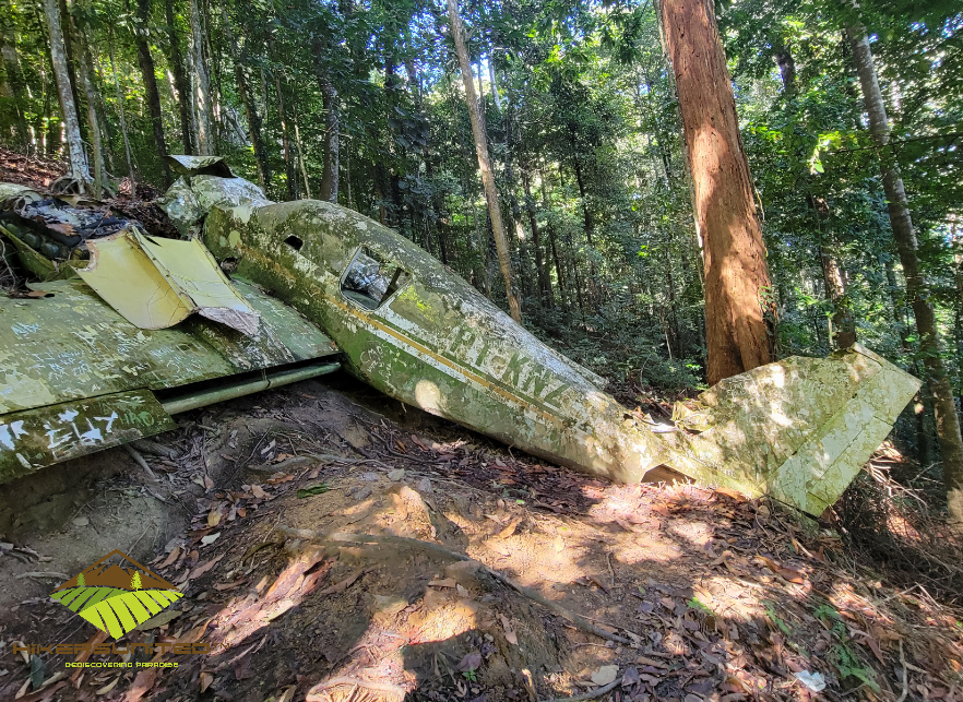
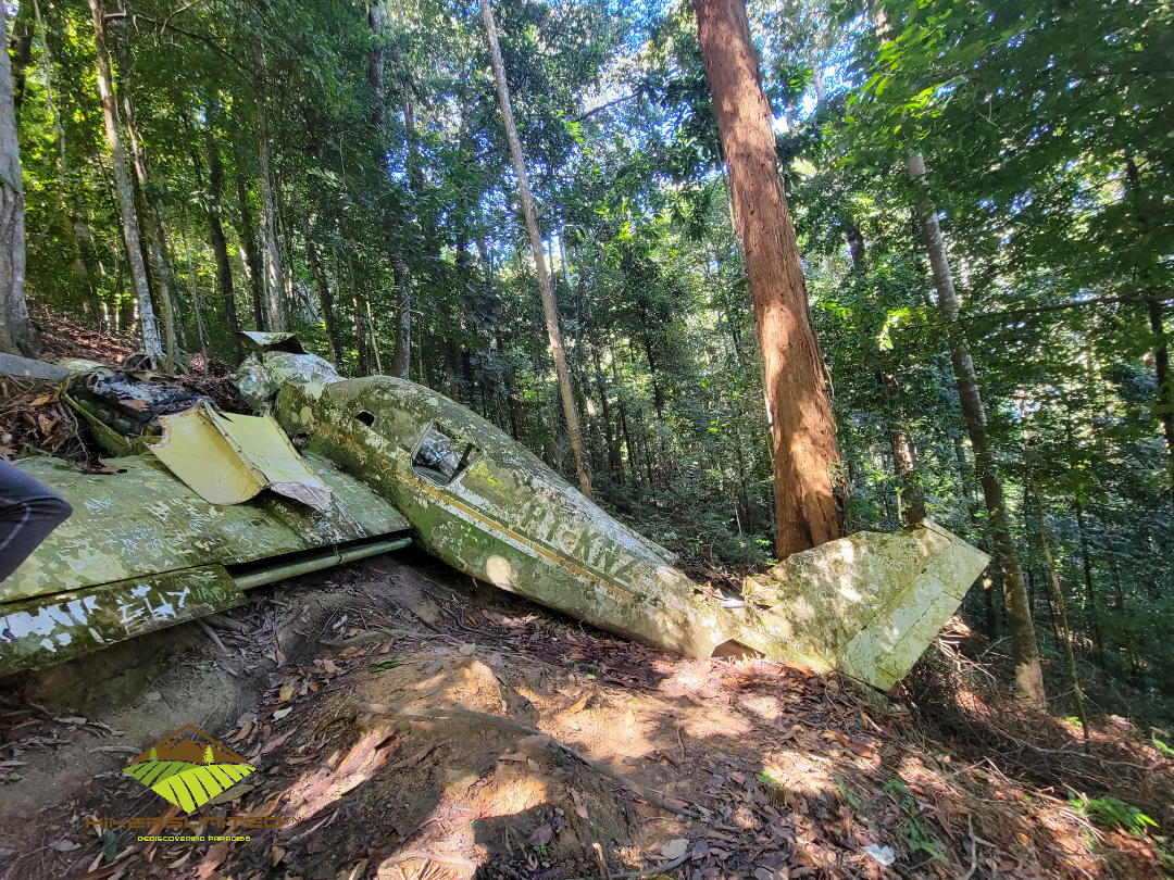
This hike is to a Piper PA-23 Aztec light aircraft that crashed into the side of the mountain in 1975 ✈️🌄. There were two persons on board and they both survived the crash and thankfully, only sustained some minor injuries. The plane which originated in St. Croix was en route to Piarco International airport. Due to bad weather 🌧encountered during the flight, the pilot was unable to contact the control tower at Piarco airport. He decided to reduce the altitude at which the aircraft was flying to see the landscape more clearly. Unfortunately, he did this right as he was reaching the Northern Range of Trinidad and in the end crashed into the mountainside in Chaguaramas. The wreckage is still there 47 years later. Can you believe it? How cool is that 😲?


The hike:
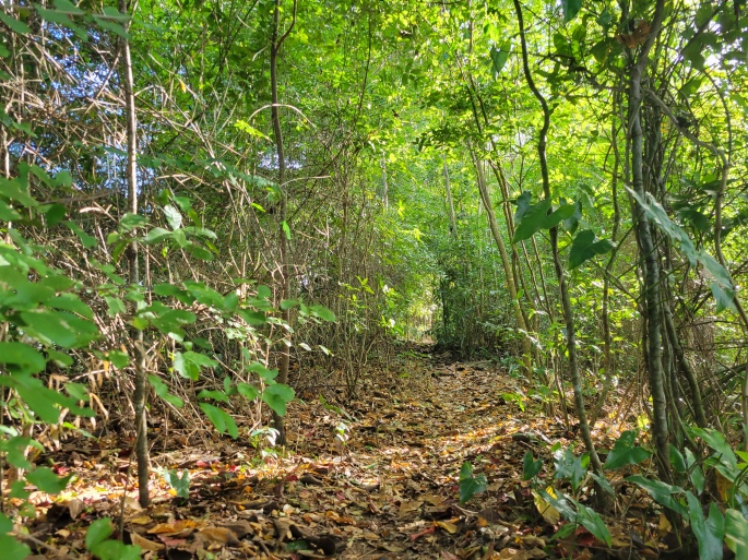
The hike to the plane crash site is moderately challenging. I will rate it as a 5 / 10 (Paria will get 7 / 10 for reference Paria Bay and Waterfall in all its glory 🙂). The hike begins in Samaan Park where you can use the Huggin Loops trail. You can also use the trail from the Bamboo Cathedral side, but we decided to start our journey in Samaan Park 🌳.
This trail is a continuous uphill trek that is gradual in some parts and steeper in others. You are literally climbing the mountain for about 4 km until you reach the top. Although it is moderately challenging, it is an absolutely breathtakingly beautiful trail that is also very breezy at some points. I love this hike 😎.

NB. As this is Chaguaramas, there are monkeys 🐵 🙈 in the trees who tend to make a lot of noise when you are passing, don’t be alarmed, we are passing through their territory.


After you reach the top of the mountain, there is a Y junction and you can either continue straight on the main trail which will take you to the Satellite and the top of Bamboo Cathedral, or take the right turn and head to the Plane Crash site. It will seem tempting to continue straight on the clear trail ahead after making the right turn, but less than a minute from the Y, there is a detour to the left which is where the trail that takes you directly to the plane crash starts (there is a picture of a plane and a sign, look out for it) 👀.
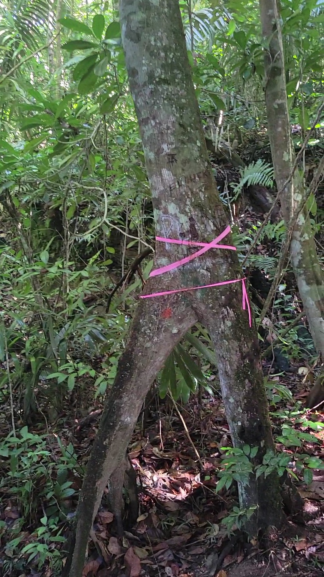

This part of the hike is quite short, you have already done most of the work and we are almost to the location of the plane 🙌. The last part of the trail is about 0.3 km and is flat and then downhill. Be careful on the downhill, yes there is a beautiful view of the ocean in the background but be careful and use the rope to assist you as you hike down. Continue to follow the ribbons and before you know it you will be seeing the plane ✈️. It was bigger than I thought….. we were so happy to find it.

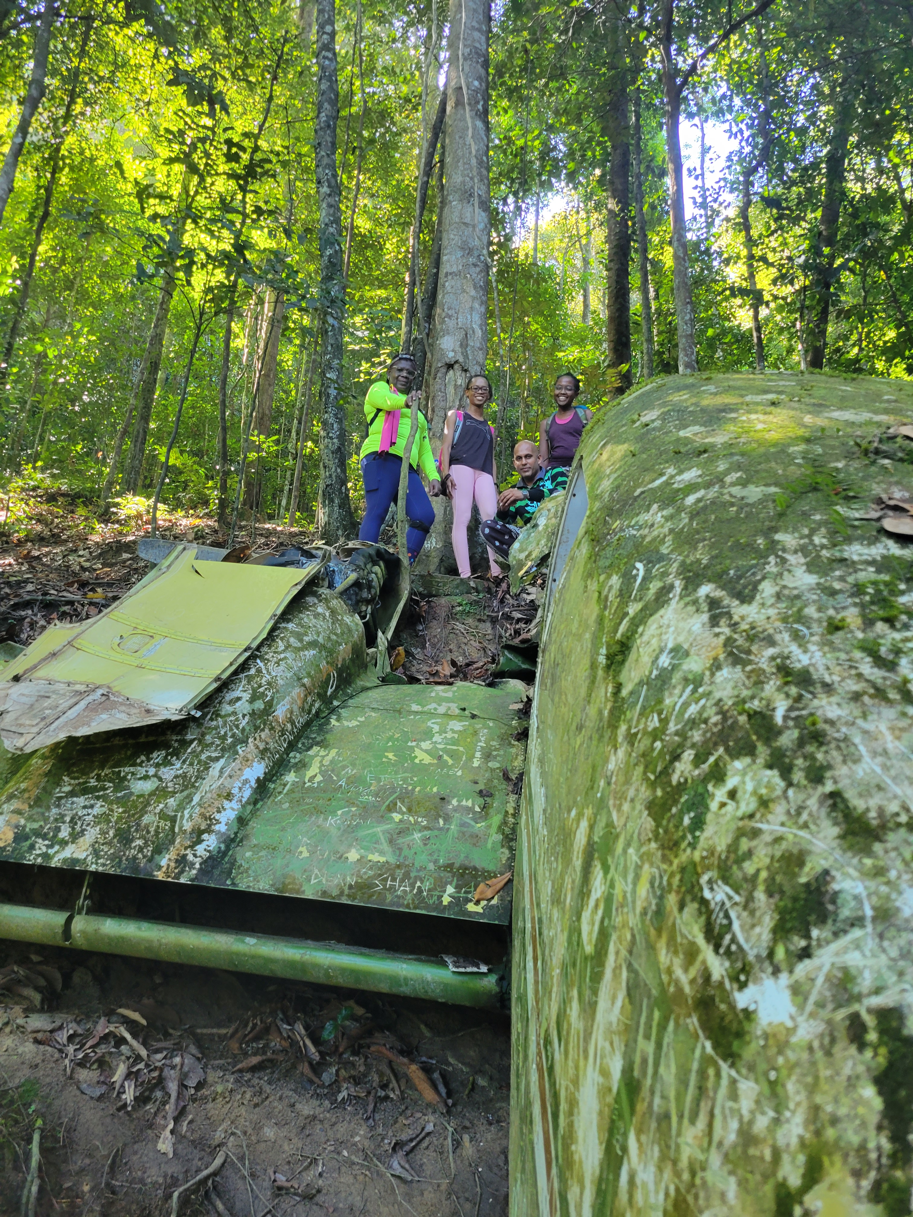
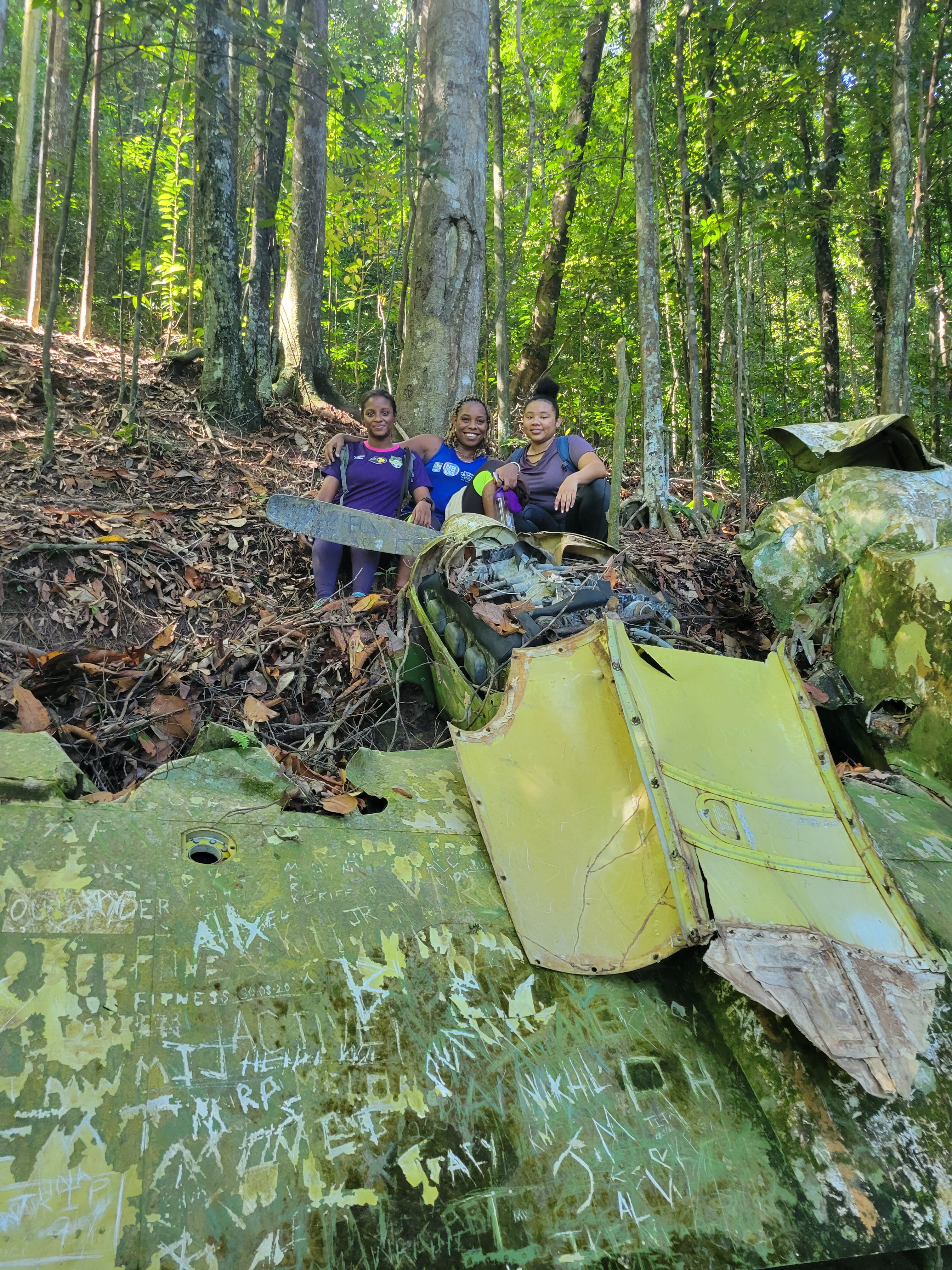

The plane crash site is a dry hike, it does not end by a waterfall or beach but it is worth the trek. I find that it is really cool to visit such a historic crash site and it is also a good workout so if you are into fitness and exercise, this is a fun hike for you to do 🥰.
Some things to note about this hike:
- Wear long sleeve pants and a long sleeve top as there are mosquitos and other insects 🦟 🦗 🐜that love to bite you on this trail. They will bite you most likely through your clothes even if you have on the long sleeve pants however so prepare to be scratching little bumps on your arms and legs for a few days after this hike. Such is the nature of some forest adventures 🌲 🌳.
- This is a hike that can take anywhere from 1hr 30 mins to 2 hrs one way, so it is advised that you do this trail in the morning 🌞 as no one wants to be in this forest after dark 🌚. Also, I suggest that you go with a group and also with a guide or someone who knows the trail. There are many trails in Chaguraramas and it is therefore very easy to get lost.
- As usual as you would for any hike, have a good breakfast 🥪 🥙 , carry some water and a snack and wear good sneakers. This is not a hike to use your sneaker that has been dry-rotting in your cupboard for 2 years.
- Have fun, take time to not only catch your breath on the way up but also to admire the beauty of this trail 🌸 🌼.

Have you visited the plane crash site before? What do you think of this hike?
Be sure to follow me on IG @cellyhikes and the crew that I hike with @hikersunited.
Much Love,
Celly
Sources of information on the history of the Plane Crash Site:
https://tt.loopnews.com/content/vandals-deface-historic-chaguaramas-plane-wreck


This looks like such a neat hike. That’s pretty impressive that the body of the plane is still intact and looks to be in pretty good shape considering how long it’s been there.
LikeLiked by 1 person
Yessss. I was shocked too and quited impressed! It is a great hike, I am sure I will be doing this trail several more times in 2022 😊
LikeLiked by 1 person
Celeste! This is my kind of hike. Hiking to waterfalls are great, but a plane crash site? Sign me up. I’m glad no one died in the crash
LikeLiked by 1 person
Yess…for your next trip here we will check it out. The trail is also just so beautiful 🥰🌿
LikeLiked by 1 person
Seems like a great hike but it maybe to difficult for me , an over sixty-fiver.
LikeLiked by 1 person
Well it really depends there are some 65+ persons who will do this hike and I won’t be able to keep up with them😰
LikeLiked by 1 person
Cool indeed. Had no idea this existed in Trinidad – your group sure do find the good places to hike to. Although it was nice, I’d prefer the reward of a nice beach or a waterfall at the end of that trail – lol! As for the sign on the tree, they might want to consider something a tad bit more durable.
LikeLiked by 2 people
Lololol true. The sign is laminated but yes something more durable will be better. Yes, most people prefer hikez tgat end with a waterfall or beach to cool down after 💦
LikeLiked by 2 people
Yes, that was the point….a cool down will definitely be necessary after all that walking and climbing! LOL!!
LikeLiked by 1 person