
A couple of Saturdays ago, I embarked upon my most challenging hike to the date to the second tallest mountain in Trinidad, El Tucuche (936 m tall) with the Fitness Walkers Hiking Club. (NB. The tallest mountain in Trinidad is El Cerro Del Aripo which is 940 m in height.) I always wanted to do this hike so I didn’t even think twice about it when I was invited on this adventure 🌄
N.B. If you want a challenging hike and are in to fitness this is surely one for you to a try 😄💪


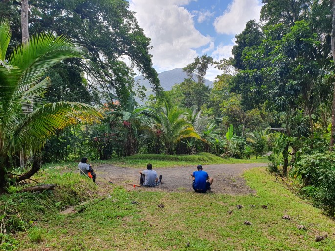
The hike started at 8 30 am on a sunny Saturday morning. A prefect day for a hike. The trail started off along a roadway which gradually sloped upwards for about 1 km before we began the real trail hike through the forest. Quite a few people from the group turned back at this point when they were told that “the real hike hasn’t even started as yet.” 😨 😰
PS. If you are having trouble on this portion of the trail, then it really doesn’t make sense to continue as you still have a very long way to go🌳This hike is harder than a hike to Paria as it is pretty much a constant uphill trek as compared to the more rolling hills of the Paria trail 🌲

Overall, the trail is fairly clear all the way to the top and well marked with yellow, pink and even red ribbons. At one point there is there is a side trail that can take you to Morang waterfall in St Joseph, however we stayed on the main trail to continue to the top of El Tucuche.


The steepest part of this trail actually has a name. It is called the Devil’s Staircase (I kid you not) 😈 because it is so steep that you need a rope to ascend it and it is surely the most perilous part of your journey to the top of the mountain. Thankfully, we were able to navigate this section of the with no mishaps. I will however hate to reach to this point on a rainy day ☔️
The Devil’s Staircase is about 2/3 of the way to the top of the mountain so we soldiered on, being sure to take frequent stops to drink water and take a deep breath.


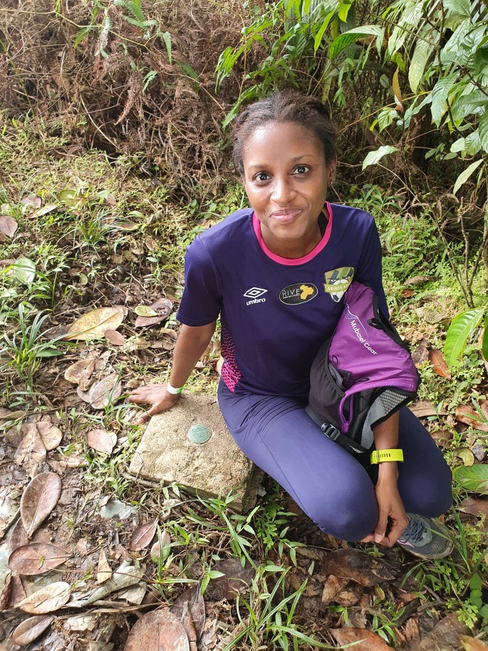
Sadly, at the top there was no view to speak of because the trees were overgrown but there was a little clearing at the top where you can sit and relax. We took some pictures here including one of the geodetic sign left by the Inter-American Geodetic Survey in 1953 marking the exact position on the Earth’s surface of El Tucuche.
Our total hiking time to the top of the mountain was 1 hr 55 mins and although we did not get the view that we wanted when we reached to the top, the joy was surely in the journey for this one. This hike was an absolute work out for me (my legs were in shambles about 2 days later) but the trail was beautiful and I enjoyed every bit of this adventure.


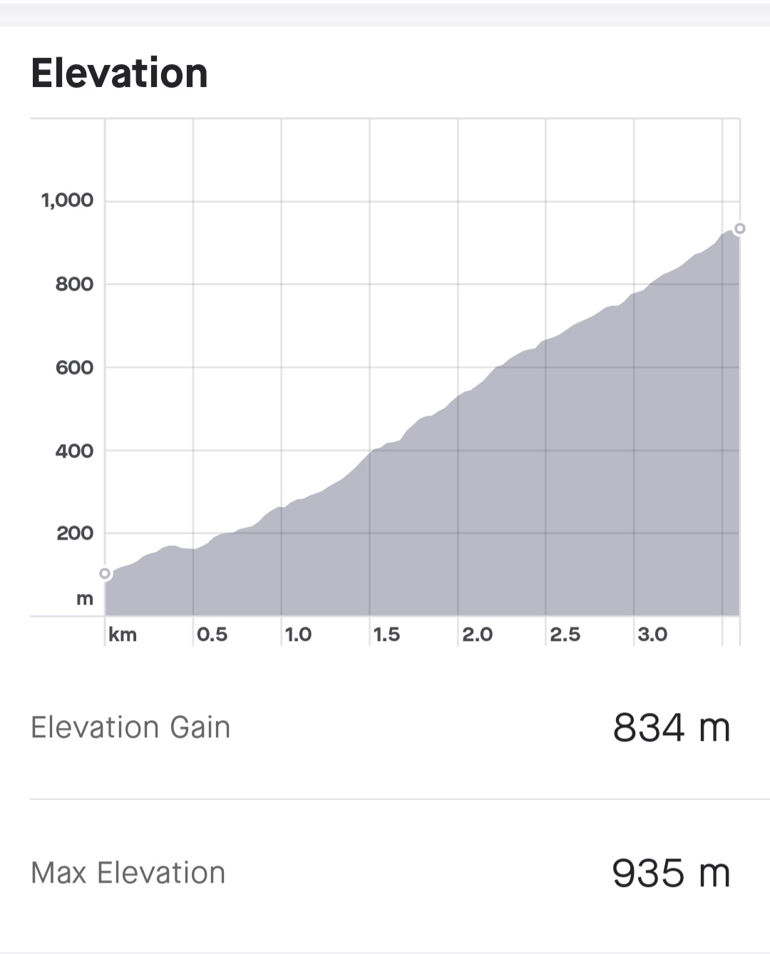
As usual the return leg of a hike is always faster and although we took 1 hr 55 mins to reach to the top, we took 1 hr 25 mins to reach back to the cars. The total distance one way was 3.63 km and the elevation gain was 834 m. This was my most difficult hike ever and I look forward to doing more hikes like this that really test my fitness level.
Have you been to the top of El Tucuche before? What is the most challenging hike that you have done?
Much Love
Celly

Wow!!! Hats off to you madam! This surely isn’t for the faint hearted. My heart would have exploded…lol!! I’ll sit this one out thanks. And then there was no beach or waterfall or anything think rewarding at the top….no thanks. But good job though.
LikeLiked by 1 person
LOLOL. No problem. Yes, most people refuse to do a hike like this unless there is some kind of water feature at the end so I understand 🙂
LikeLike
Congrats. Walking in the Botanical Gardens is enough for me.
LikeLiked by 1 person
Thank you…. I am still waiting for you to join us on a trail sometime 🙂
LikeLike
well done! el tucuche is always a challenge for me! i usu take about 3hr and def feel it in my legs in d fol days. a short detour to the morang pools wil lead to a lovely waterfall and pool as an additional reward for all the climbing. i last went oct2020 and altho the trail was stil beautiful the mosquitoes were not! so dry season sounds the way to go 🙂 thank you for your enjoyable and informative articles!
LikeLike
Contact me. i would like to know more about the trail head.
LikeLike
Information was very helpful..I did it yesterday. Was a bit dangerous with the rope and wet leaves as it rained the afternoon before.
LikeLiked by 1 person
Thank you. Yes….when that trail is wet it will.surely be tricky but glad you made it safely. Thanks for reading my blog post 🙏😊
LikeLike
someone has cleared some of the “bush” at the top so now there’s a gr8 view of las cuevas. and “d flag gentz” hav placed a national flag to welcome and inspire 🙂 worth anothr trip up i wud say, enjoy!
LikeLike
I went up twice in the late 60’s early 70’s. The second trip we even camped up there. It was cold! No ropes then :^).
LikeLike
First time I am seeing this vlog.
LikeLike